
71546417103__DCA5D542-718B-4789-8FCF-5100CE67B1DE.jpeg
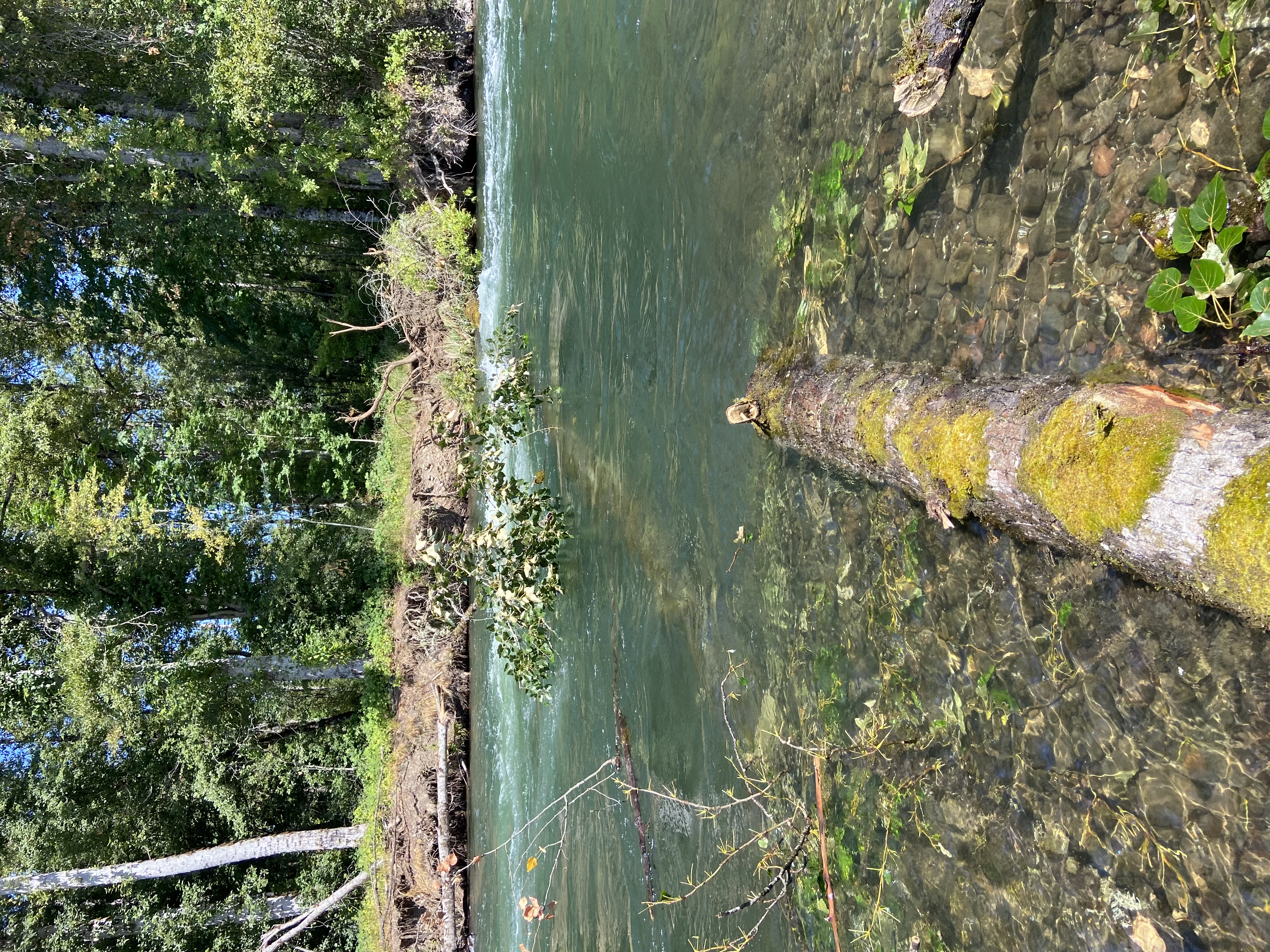
Water Obstruction: Willamette River below Clearwater Landing (Photo) – 09/03/23
The Lane County Sheriff’s Office is advising the public of an obstruction on the Willamette River approximately one quarter of a mile below Clearwater landing. A tree has come down across the channel rendering it unnavigable safely. Recreational boaters are urged to avoid this section of river until the hazard can be mitigated. Anyone insistent on floating this section of the river are cautioned to stay as far river left as possible and consider portaging (exiting the river) when passing the hazard.
Visit www.oregon.gov/osmb for the latest information on water obstructions within Oregon.
The following areas are being reduced to a Level 2 (Be Set) evacuation notice:
🟡North of Highway 126 from Drury Ln. east to Scott Creek Rd., including Paradise Campground and North Belknap Hot Springs Rd.
—
The following areas remain on a Level 3 (GO NOW) evacuation notice:
🔴Horse Creek Rd. east of the Horse Creek Bridge.
🔴Foley Hot Springs
🔴Mona Campground.
🔴Lookout Campground
🔴H.J. Andrews Headquarters
The area west of Hwy. 126 from Scott Rd. north into Linn County. (Additional evacuations are in Linn County)
Level 3 (GO NOW) Evacuation Notice: LEAVE IMMEDIATELY. Danger is current or imminent and you should evacuate now. If you choose to ignore this notice, emergency services may not be able to assist you further. DO NOT DELAY leaving to gather items or protect your home. THIS WILL BE THE LAST NOTICE YOU RECEIVE. Entry to evacuated areas may be denied until it is safe.
—
The following areas remain on a Level 2 (Be Set) evacuation notice:
🟡Hwy. 242 to the 220 spur
🟡Belknap Springs Rd. S.
🟡Yale Ln.
🟡Camp Yale Rd.
🟡Horse Creek Rd. west and north of Horse Creek Bridge.
🟡Hall Rd.
🟡Sullivan Ln.
🟡Alma Dr.
🟡Old Foley Ridge Rd.
🟡5600blk of Delta Dr.
🟡Areas south of McKenzie Hwy. from milepost 50.5 to milepost 54
🟡Horse Creek Lodge
🟡North Bank Rd.
🟡Areas east of the McKenzie Bridge to, and including Drury Ln. north of Hwy. 126, but south of the McKenzie River.
🟡Areas north of Hwy. 126 east of the .5 mile mark on Mill Creek Rd. to the east end of Taylor Rd.
🟡Areas south of Hwy 126 from the Hwy 242 junction to Scott Rd.
🟡The area east of Hwy. 126 from Scott Rd. north into Linn County. (Additional evacuations are in Linn County)
🟡Areas north of Hwy. 126 west of the .5 mile mark on Mill Creek Rd. to Blue River
🟡Reservoir Rd. at the 1501 junction.
🟡The area south of Hwy 126 to the McKenzie River from the east end of McKenzie River Dr. to the McKenzie River Bridge just east of Taylor Rd.
🟡Residents on a Level 2 (Be Set) evacuation notice who need assistance with large animal sheltering should call Lane County Animal Services at 541-285-8227.
Level 2 means you must prepare to leave at a moment’s notice, and this may be the only notice that you receive. Public safety personnel cannot guarantee they will be able to notify you if conditions rapidly deteriorate.
—
The following areas remain on a Level 1 (Be Ready) evacuation notice:
🟢Areas south of Hwy. 126 from Blue River Reservoir Rd. east to the east end of McKenzie River Dr.
🟢The area south of Hwy 126 from the McKenzie River Bridge just east of Taylor Rd. to Scott Creek Rd.
🟢McKenzie River Dr. and areas directly to the south and east.
Level 1 means you should be aware of the danger that exists in your area, monitor local media outlets and telephone devices to receive further information.
—
*Evacuation notices are also in effect in Linn County related to the Lookout Fire. Visit www.LinnSheriff.org or @LinnSheriff on Facebook for evacuation notices within Linn County.
This is the time for preparation and precautionary movement of persons with special needs, mobile property, pets and livestock.
An evacuation map is available at www.LaneCounty.org/LookoutFire
Residents are encouraged to sign up for emergency alerts at www.LaneAlerts.org

SCAM_ALERT.jpg
Scammers impersonating Sheriff’s Office employees (Photo) – 08/31/23
We have received recent reports of a scam in our community.
The scammers commonly identify themselves as employees of the Lane County Sheriff’s Office, either verbally, by text, or by email. The scammers will then make claims that there are warrants, missed jury duty, or unsettled legal business that involve the victim or someone the victim knows and ask for personal or financial information. In some instances the scammers appear to call from official phone numbers and/or provide fraudulent callback numbers with voicemail inboxes.
***Please be aware that the Lane County Sheriff’s Office will never ask for money, awards, or compensation of any type over the telephone, by text or email.***
If you are contacted by someone claiming to be a Lane County Sheriff’s Office employee and you think you are being scammed, please contact our dispatch center at 541-682-4150 opt. 1.
LEVEL_2.jpg
Grizzly Fire Prompts Level 2 (Be Set) Evacuation Notice (Photo) – 08/31/23
Increased fire behavior on the Grizzly Fire, burning approximately 20 miles southeast of Dorena has prompted a Level 2 (Be Set) evacuation notice for the following areas:
🟡 All private lands & mining claims in the Bohemia areas within the Cottage Grove Ranger District of the Umpqua National Forest.
Level 2 means you must prepare to leave at a moment’s notice, and this may be the only notice that you receive. Public safety personnel cannot guarantee they will be able to notify you if conditions rapidly deteriorate.
—
This is the time for preparation and precautionary movement of persons with special needs, mobile property, pets and livestock.
An evacuation map is available at https://www.lanecounty.org/news/brice_dinner_grizzly_fires
Residents are encouraged to sign up for emergency alerts at www.LaneAlerts.org
—
The United States Forest Service has additionally implemented a forest closure for the entire Cottage Grove Ranger District.
LEVEL_3.png
08/30/23 Spot Fire from Lookout Fire Prompts Level 3 (GO NOW) Evacuation Notice (Photo) – 08/30/23
*Correction – The heading should state ‘08/30/23’
The following areas are being upgraded to a Level 3 (GO NOW) evacuation notice:
Increased fire behavior on the Lookout Fire, including a spot fire just east of Highway 126 (Clearlake Cutoff) near Boulder Creek Rd., is prompting an increase in evacuation levels from Level 2 (Be Set) to Level 3 (GO NOW) for the following area:
🔴North of Highway 126 from Drury Ln. east to Scott Creek Rd., including Paradise Campground and North Belknap Hot Springs Rd.
—
The following areas remain on a Level 3 (GO NOW) evacuation notice:
🔴Horse Creek Rd. east of the Horse Creek Bridge.
🔴Foley Hot Springs
🔴Mona Campground.
🔴Lookout Campground
🔴H.J. Andrews Headquarters
The area west of Hwy. 126 from Scott Rd. north into Linn County. (Additional evacuations are in Linn County)
Level 3 (GO NOW) Evacuation Notice: LEAVE IMMEDIATELY. Danger is current or imminent and you should evacuate now. If you choose to ignore this notice, emergency services may not be able to assist you further. DO NOT DELAY leaving to gather items or protect your home. THIS WILL BE THE LAST NOTICE YOU RECEIVE. Entry to evacuated areas may be denied until it is safe.
—
The following areas remain on a Level 2 (Be Set) evacuation notice:
🟡Hwy. 242 to the 220 spur
🟡Belknap Springs Rd. S.
🟡Yale Ln.
🟡Camp Yale Rd.
🟡Horse Creek Rd. west and north of Horse Creek Bridge.
🟡Hall Rd.
🟡Sullivan Ln.
🟡Alma Dr.
🟡Old Foley Ridge Rd.
🟡5600blk of Delta Dr.
🟡Areas south of McKenzie Hwy. from milepost 50.5 to milepost 54
🟡Horse Creek Lodge
🟡North Bank Rd.
🟡Areas east of the McKenzie Bridge to, and including Drury Ln. north of Hwy. 126, but south of the McKenzie River.
🟡Areas north of Hwy. 126 east of the .5 mile mark on Mill Creek Rd. to the east end of Taylor Rd.
🟡Areas south of Hwy 126 from the Hwy 242 junction to Scott Rd.
🟡The area east of Hwy. 126 from Scott Rd. north into Linn County. (Additional evacuations are in Linn County)
🟡Areas north of Hwy. 126 west of the .5 mile mark on Mill Creek Rd. to Blue River
🟡Reservoir Rd. at the 1501 junction.
🟡The area south of Hwy 126 to the McKenzie River from the east end of McKenzie River Dr. to the McKenzie River Bridge just east of Taylor Rd.
🟡Residents on a Level 2 (Be Set) evacuation notice who need assistance with large animal sheltering should call Lane County Animal Services at 541-285-8227.
🟡Level 2 means you must prepare to leave at a moment’s notice, and this may be the only notice that you receive. Public safety personnel cannot guarantee they will be able to notify you if conditions rapidly deteriorate.
—
The following areas remain on a Level 1 (Be Ready) evacuation notice:
🟢Areas south of Hwy. 126 from Blue River Reservoir Rd. east to the east end of McKenzie River Dr.
🟢The area south of Hwy 126 from the McKenzie River Bridge just east of Taylor Rd. to Scott Creek Rd.
🟢McKenzie River Dr. and areas directly to the south and east.
Level 1 means you should be aware of the danger that exists in your area, monitor local media outlets and telephone devices to receive further information.
—
*Evacuation notices are also in effect in Linn County related to the Lookout Fire. Visit www.LinnSheriff.org or @LinnSheriff on Facebook for evacuation notices within Linn County.
This is the time for preparation and precautionary movement of persons with special needs, mobile property, pets and livestock.
An evacuation map is available at www.LaneCounty.org/LookoutFire
Residents are encouraged to sign up for emergency alerts at www.LaneAlerts.org
The following areas are being reduced to a Level 1 (Be Ready) evacuation notification:
🟢 Peninsula Road east of Timber Creek
🟢 Big Fall Creek Road east of the intersection with Peninsula
The following areas remain on a Level 1 (Be Ready) evacuation notification:
🟢 Winberry Creek Road east of milepost 4.0
🟢 Big Fall Creek Road east of Winberry Creek Road to Peninsula Road
🟢 Peninsula Road along the south of Fall Creek Reservoir to Timber Creek
Level 1 means you should be aware of the danger that exists in your area, monitor local media outlets and telephone devices to receive further information
—
Public safety personnel cannot guarantee they will be able to notify you if conditions rapidly deteriorate. Continue to closely monitor your phone, local media and www.LaneCountyOR.gov/Bedrock for information.
The following areas are being reduced to a Level 1 (Be Ready) evacuation notification:
🟢 Winberry Creek Road east of milepost 4.0
🟢 Big Fall Creek Road east of Winberry Creek Road to Peninsula Road
🟢 Peninsula Road along the south of Fall Creek Reservoir to Timber Creek
Level 1 means you should be aware of the danger that exists in your area, monitor local media outlets and telephone devices to receive further information
—
The following areas remain on a Level 2 (Be Set) evacuation notification:
🟡 Peninsula Road east of Timber Creek
🟡 Big Fall Creek Road east of the intersection with Peninsula
Level 2 means: You must prepare to leave at a moment’s notice, and this may be the only notice that you receive.
Public safety personnel cannot guarantee they will be able to notify you if conditions rapidly deteriorate. Continue to closely monitor your phone, local media and www.LaneCountyOR.gov/Bedrock for information.
The following areas are being upgraded to a Level 3 (GO NOW) evacuation notice:
![]() Horse Creek Rd. east of the Horse Creek Bridge.
Horse Creek Rd. east of the Horse Creek Bridge.
![]() Foley Hot Springs
Foley Hot Springs
The following areas are being upgraded to a Level 2 (Be Set) evacuation notice:
![]() Hwy. 242 to the 220 spur
Hwy. 242 to the 220 spur
![]() Belknap Springs Rd. S.
Belknap Springs Rd. S.
![]() Yale Ln.
Yale Ln.
![]() Camp Yale Rd.
Camp Yale Rd.
—
The following areas remain on a Level 3 (GO NOW) evacuation notice:
![]() Mona Campground.
Mona Campground.
![]() Lookout Campground
Lookout Campground
![]() H.J. Andrews Headquarters
H.J. Andrews Headquarters
![]() The area west of Hwy. 126 from Scott Rd. north into Linn County. (Additional evacuations are in Linn County)
The area west of Hwy. 126 from Scott Rd. north into Linn County. (Additional evacuations are in Linn County)
Level 3 (GO NOW) Evacuation Notice: LEAVE IMMEDIATELY. Danger is current or imminent and you should evacuate now. If you choose to ignore this notice, emergency services may not be able to assist you further. DO NOT DELAY leaving to gather items or protect your home. THIS WILL BE THE LAST NOTICE YOU RECEIVE. Entry to evacuated areas may be denied until it is safe.
*Hwy 126 will be remaining open for traffic passing through for the time being.
—
The following areas remain on a Level 2 (Be Set) evacuation notice:
![]() Horse Creek Rd. west and north of the Horse Creek Bridge.
Horse Creek Rd. west and north of the Horse Creek Bridge.
![]() Hall Rd.
Hall Rd.
![]() Sullivan Ln.
Sullivan Ln.
![]() Alma Dr.
Alma Dr.
![]() Old Foley Ridge Rd.
Old Foley Ridge Rd.
![]() 5600blk of Delta Dr.
5600blk of Delta Dr.
![]() Areas south of McKenzie Hwy. from milepost 50.5 to milepost 54
Areas south of McKenzie Hwy. from milepost 50.5 to milepost 54
![]() Horse Creek Lodge
Horse Creek Lodge
![]() North Bank Rd.
North Bank Rd.
![]() Areas east of the McKenzie Bridge to, and including Drury Ln. north of Hwy. 126, but south of the McKenzie River.
Areas east of the McKenzie Bridge to, and including Drury Ln. north of Hwy. 126, but south of the McKenzie River.
![]() Areas north of Hwy. 126 east of the .5 mile mark on Mill Creek Rd. to the east end of Taylor Rd.
Areas north of Hwy. 126 east of the .5 mile mark on Mill Creek Rd. to the east end of Taylor Rd.
![]() Hwy 126 from the Hwy 242 junction to Scott Rd.
Hwy 126 from the Hwy 242 junction to Scott Rd.
![]() Belknap Hot Springs Rd.
Belknap Hot Springs Rd.
![]() The area east of Hwy. 126 from Scott Rd. north into Linn County. (Additional evacuations are in Linn County)
The area east of Hwy. 126 from Scott Rd. north into Linn County. (Additional evacuations are in Linn County)
![]() Areas north of Hwy. 126 west of the .5 mile mark on Mill Creek Rd. to Blue River
Areas north of Hwy. 126 west of the .5 mile mark on Mill Creek Rd. to Blue River
Reservoir Rd. at the 1501 junction.
![]() The area south of Hwy 126 to the McKenzie River from the east end of McKenzie River Dr. to the McKenzie River Bridge just east of Taylor Rd.
The area south of Hwy 126 to the McKenzie River from the east end of McKenzie River Dr. to the McKenzie River Bridge just east of Taylor Rd.
Residents on a Level 2 (Be Set) evacuation notice who need assistance with large animal sheltering should call Lane County Animal Services at 541-285-8227.
Level 2 means you must prepare to leave at a moment’s notice, and this may be the only notice that you receive. Public safety personnel cannot guarantee they will be able to notify you if conditions rapidly deteriorate.
—
The following areas remain on a Level 1 (Be Ready) evacuation notice:
![]() Areas south of Hwy. 126 from Blue River Reservoir Rd. east to the east end of McKenzie River Dr.
Areas south of Hwy. 126 from Blue River Reservoir Rd. east to the east end of McKenzie River Dr.
![]() The area south of Hwy 126 from the McKenzie River Bridge just east of Taylor Rd. to Scott Creek Rd.
The area south of Hwy 126 from the McKenzie River Bridge just east of Taylor Rd. to Scott Creek Rd.
![]() McKenzie River Dr. and areas directly to the south and east.
McKenzie River Dr. and areas directly to the south and east.
Level 1 means you should be aware of the danger that exists in your area, monitor local media outlets and telephone devices to receive further information.
*Evacuation notices are also in effect in Linn County related to the Lookout Fire. Visit www.LinnSheriff.org or @LinnSheriff on Facebook for evacuation notices within Linn County.
This is the time for preparation and precautionary movement of persons with special needs, mobile property, pets and livestock.
An evacuation map is available at www.LaneCounty.org/LookoutFire
Residents are encouraged to sign up for emergency alerts at www.LaneAlerts.org
The Lane County Sheriff’s Office has issued a Level 3 (GO NOW) evacuation notice for the Mink Lake basin in the Three Sisters Wilderness. There is a fast-moving wildfire just north of Penn Lake.
Everyone in that area should leave immediately.
A wireless emergency alert has been issued for that area. If you have friends or family that you know are in the Mink Lake basin area, please attempt to contact them and make them aware of the evacuation. Cell phone service is limited; however, satellite devices may work.
Level 3 (GO NOW) means LEAVE IMMEDIATELY. Danger is current or imminent and you should evacuate now. If you choose to ignore this notice, emergency services may not be able to assist you further. DO NOT DELAY leaving to gather items. THIS WILL BE THE LAST NOTICE YOU RECEIVE. Entry to evacuated areas may be denied until it is safe.
###
The following areas are being issued a Level 2 (Be Set) evacuation notice:
🟡 Horse Creek Rd.
🟡 Hall Rd.
🟡 Sullivan Ln.
🟡 Alma Dr.
🟡 Old Foley Ridge Rd.
🟡 5600blk of Delta Dr.
🟡 Areas south of McKenzie Hwy. from milepost 50.5 to milepost 54
🟡 Horse Creek Lodge
🟡 Foley Hot Springs
–
The following areas remain on a Level 3 (GO NOW) evacuation notice:
🔴Mona Campground.
🔴Lookout Campground
🔴H.J. Andrews Headquarters
🔴The area west of Hwy. 126 from Scott Rd. north into Linn County. (Additional evacuations are in Linn County)
Level 3 (GO NOW) Evacuation Notice: LEAVE IMMEDIATELY. Danger is current or imminent and you should evacuate now. If you choose to ignore this notice, emergency services may not be able to assist you further. DO NOT DELAY leaving to gather items or protect your home. THIS WILL BE THE LAST NOTICE YOU RECEIVE. Entry to evacuated areas may be denied until it is safe.
*Hwy 126 will be remaining open for traffic passing through for the time being.
—
The following areas remain at a Level 2 (Be Set) evacuation notice:
🟡North Bank Rd.
🟡Areas east of the McKenzie Bridge to, and including Drury Ln. north of Hwy. 126, but south of the McKenzie River.
🟡Areas north of Hwy. 126 east of the .5 mile mark on Mill Creek Rd. to the east end of Taylor Rd.
🟡 Hwy 126 from the Hwy 242 junction to Scott Rd.
🟡 Belknap Hot Springs Rd.
🟡 The area east of Hwy. 126 from Scott Rd. north into Linn County. (Additional evacuations are in Linn County)
🟡Areas north of Hwy. 126 west of the .5 mile mark on Mill Creek Rd. to Blue River
Reservoir Rd. at the 1501 junction.
🟡The area south of Hwy 126 to the McKenzie River from the east end of McKenzie River Dr. to the McKenzie River Bridge just east of Taylor Rd.
Residents on a Level 2 (Be Set) evacuation notice who need assistance with large animal sheltering should call Lane County Animal Services at 541-285-8227.
Level 2 means you must prepare to leave at a moment’s notice, and this may be the only notice that you receive. Public safety personnel cannot guarantee they will be able to notify you if conditions rapidly deteriorate.
—
The following areas remain on a Level 1 (Be Ready) evacuation notice:
🟢 Areas south of Hwy. 126 from Blue River Reservoir Rd. east to the east end of McKenzie River Dr.
🟢 The area south of Hwy 126 from the McKenzie River Bridge just east of Taylor Rd. to Scott Creek Rd.
🟢 McKenzie River Dr. and areas directly to the south and east.
🟢 Belknap Springs Rd. S.
Level 1 means you should be aware of the danger that exists in your area, monitor local media outlets and telephone devices to receive further information.
*Evacuation notices are also in effect in Linn County related to the Lookout Fire. Visit www.LinnSheriff.org or @LinnSheriff on Facebook for evacuation notices within Linn County.
This is the time for preparation and precautionary movement of persons with special needs, mobile property, pets and livestock.
An evacuation map is available at www.LaneCounty.org/LookoutFire
Residents are encouraged to sign up for emergency alerts at www.LaneAlerts.org
On 08/24/2023 at 2:00pm, a Lane County Sheriff’s Deputy working within a housing unit at the Lane County Jail discovered a male adult-in-custody (AIC) unresponsive in his cell during hourly checks. His last check had been completed at 1:00pm. The male had a ligature tied around his neck and was unconscious and not breathing. The deputy removed the ligature and immediately began life-saving efforts. Emergency medical assistance arrived and despite continued life-saving efforts the male did not survive.
Detectives along with the Lane County Medical Examiner’s Office responded to the scene and began an investigation. All indications at this point are that the male died as the result of apparent suicide. Investigators with the Medical Examiner’s Office are continuing the investigation into the official cause of his death. A post-mortem examination is scheduled for today.
The male is identified as 33-year-old Joshua William Cates. Cates was convicted in June in the Lane County Circuit Court for Sex Abuse in the First Degree, Attempted Rape in the First Degree, and Assault in the Second Degree. He was pending sentencing on these charges at the time of his death.
The following areas are being reduced from a Level 3 (GO NOW) evacuation notice to a Level 2 (Be Set) evacuation notice:
🟡North Bank Rd.
The following areas remain on a Level 3 (GO NOW) evacuation notice:
🔴Mona Campground.
🔴Lookout Campground
🔴H.J. Andrews Headquarters
🔴The area west of Hwy. 126 from Scott Rd. north into Linn County. (Additional evacuations are in Linn County)
Level 3 (GO NOW) Evacuation Notice: LEAVE IMMEDIATELY. Danger is current or imminent and you should evacuate now. If you choose to ignore this notice, emergency services may not be able to assist you further. DO NOT DELAY leaving to gather items or protect your home. THIS WILL BE THE LAST NOTICE YOU RECEIVE. Entry to evacuated areas may be denied until it is safe.
*Hwy 126 will be remaining open for traffic passing through for the time being.
—
The following areas remain at a Level 2 (Be Set) evacuation notice:
🟡Areas east of the McKenzie Bridge to, and including Drury Ln. north of Hwy. 126, but south of the McKenzie River.
🟡Areas north of Hwy. 126 east of the .5 mile mark on Mill Creek Rd. to the east end of Taylor Rd.
🟡 Hwy 126 from the Hwy 242 junction to Scott Rd.
🟡 Belknap Hot Springs Rd.
🟡 The area east of Hwy. 126 from Scott Rd. north into Linn County. (Additional evacuations are in Linn County)
🟡Areas north of Hwy. 126 west of the .5 mile mark on Mill Creek Rd. to Blue River
Reservoir Rd. at the 1501 junction.
🟡The area south of Hwy 126 to the McKenzie River from the east end of McKenzie River Dr. to the McKenzie River Bridge just east of Taylor Rd.
Residents on a Level 2 (Be Set) evacuation notice who need assistance with large animal sheltering should call Lane County Animal Services at 541-285-8227.
Level 2 means you must prepare to leave at a moment’s notice, and this may be the only notice that you receive. Public safety personnel cannot guarantee they will be able to notify you if conditions rapidly deteriorate.
—
The following areas remain on a Level 1 (Be Ready) evacuation notice:
🟢 Areas south of Hwy. 126 from Blue River Reservoir Rd. east to the east end of McKenzie River Dr.
🟢 The area south of Hwy 126 from the McKenzie River Bridge just east of Taylor Rd. to Scott Creek Rd.
🟢 McKenzie River Dr. and areas directly to the south and east.
🟢 Belknap Springs Rd. S.
Level 1 means you should be aware of the danger that exists in your area, monitor local media outlets and telephone devices to receive further information.
*Evacuation notices are also in effect in Linn County related to the Lookout Fire. Visit www.LinnSheriff.org or @LinnSheriff on Facebook for evacuation notices within Linn County.
This is the time for preparation and precautionary movement of persons with special needs, mobile property, pets and livestock.
An evacuation map is available at www.LaneCounty.org/LookoutFire
Residents are encouraged to sign up for emergency alerts at www.LaneAlerts.org
The following areas are being reduced from a Level 3 (GO NOW) evacuation notice to a Level 2 (Be Set) evacuation notice:
🟡Areas east of the McKenzie Bridge to, and including Drury Ln. north of Hwy. 126, but south of the McKenzie River.
The following areas remain on a Level 3 (GO NOW) evacuation notice:
🔴North Bank Rd.
🔴Mona Campground.
🔴Lookout Campground
🔴H.J. Andrews Headquarters
🔴The area west of Hwy. 126 from Scott Rd. north into Linn County. (Additional evacuations are in Linn County)
Level 3 (GO NOW) Evacuation Notice: LEAVE IMMEDIATELY. Danger is current or imminent and you should evacuate now. If you choose to ignore this notice, emergency services may not be able to assist you further. DO NOT DELAY leaving to gather items or protect your home. THIS WILL BE THE LAST NOTICE YOU RECEIVE. Entry to evacuated areas may be denied until it is safe.
*Hwy 126 will be remaining open for traffic passing through for the time being.
—
The following areas remain at a Level 2 (Be Set) evacuation notice:
🟡Areas north of Hwy. 126 east of the .5 mile mark on Mill Creek Rd. to the east end of Taylor Rd.
🟡 Hwy 126 from the Hwy 242 junction to Scott Rd.
🟡 Belknap Hot Springs Rd.
🟡 The area east of Hwy. 126 from Scott Rd. north into Linn County. (Additional evacuations are in Linn County)
🟡Areas north of Hwy. 126 west of the .5 mile mark on Mill Creek Rd. to Blue River
Reservoir Rd. at the 1501 junction.
🟡The area south of Hwy 126 to the McKenzie River from the east end of McKenzie River Dr. to the McKenzie River Bridge just east of Taylor Rd.
Residents on a Level 2 (Be Set) evacuation notice who need assistance with large animal sheltering should call Lane County Animal Services at 541-285-8227.
Level 2 means you must prepare to leave at a moment’s notice, and this may be the only notice that you receive. Public safety personnel cannot guarantee they will be able to notify you if conditions rapidly deteriorate.
—
The following areas remain on a Level 1 (Be Ready) evacuation notice:
🟢 Areas south of Hwy. 126 from Blue River Reservoir Rd. east to the east end of McKenzie River Dr.
🟢 The area south of Hwy 126 from the McKenzie River Bridge just east of Taylor Rd. to Scott Creek Rd.
🟢 McKenzie River Dr. and areas directly to the south and east.
🟢 Belknap Springs Rd. S.
Level 1 means you should be aware of the danger that exists in your area, monitor local media outlets and telephone devices to receive further information.
*Evacuation notices are also in effect in Linn County related to the Lookout Fire. Visit www.LinnSheriff.org or @LinnSheriff on Facebook for evacuation notices within Linn County.
This is the time for preparation and precautionary movement of persons with special needs, mobile property, pets and livestock.
An evacuation map is available at www.LaneCounty.org/LookoutFire
Residents are encouraged to sign up for emergency alerts at www.LaneAlerts.org
The following areas are being reduced from a Level 3 (GO NOW) evacuation notice to a Level 2 (Be Set) evacuation notice:
🟡Areas north of Hwy. 126 east of the .5 mile mark on Mill Creek Rd. to the east end of Taylor Rd.
The following areas remain on a Level 3 (GO NOW) evacuation notice:
🔴North Bank Rd.
🔴Areas north of Hwy. 126 between North Bank Rd. and Drury Ln.
🔴Mona Campground.
🔴Lookout Campground
🔴H.J. Andrews Headquarters
🔴The area west of Hwy. 126 from Scott Rd. north into Linn County. (Additional evacuations are in Linn County)
Level 3 (GO NOW) Evacuation Notice: LEAVE IMMEDIATELY. Danger is current or imminent and you should evacuate now. If you choose to ignore this notice, emergency services may not be able to assist you further. DO NOT DELAY leaving to gather items or protect your home. THIS WILL BE THE LAST NOTICE YOU RECEIVE. Entry to evacuated areas may be denied until it is safe.
*Hwy 126 will be remaining open for traffic passing through for the time being.
—
The following areas remain at a Level 2 (Be Set) evacuation notice:
🟡 Hwy 126 from the Hwy 242 junction to Scott Rd.
🟡 Belknap Hot Springs Rd.
🟡 The area east of Hwy. 126 from Scott Rd. north into Linn County. (Additional evacuations are in Linn County)
🟡Areas north of Hwy. 126 west of the .5 mile mark on Mill Creek Rd. to Blue River
Reservoir Rd. at the 1501 junction.
🟡The area south of Hwy 126 to the McKenzie River from the east end of McKenzie River Dr. to the McKenzie River Bridge just east of Taylor Rd.
Residents on a Level 2 (Be Set) evacuation notice who need assistance with large animal sheltering should call Lane County Animal Services at 541-285-8227.
Level 2 means you must prepare to leave at a moment’s notice, and this may be the only notice that you receive. Public safety personnel cannot guarantee they will be able to notify you if conditions rapidly deteriorate.
—
The following areas remain on a Level 1 (Be Ready) evacuation notice:
🟢 Areas south of Hwy. 126 from Blue River Reservoir Rd. east to the east end of McKenzie River Dr.
🟢 The area south of Hwy 126 from the McKenzie River Bridge just east of Taylor Rd. to Scott Creek Rd.
🟢 McKenzie River Dr. and areas directly to the south and east.
🟢 Belknap Springs Rd. S.
Level 1 means you should be aware of the danger that exists in your area, monitor local media outlets and telephone devices to receive further information.
*Evacuation notices are also in effect in Linn County related to the Lookout Fire. Visit www.LinnSheriff.org or @LinnSheriff on Facebook for evacuation notices within Linn County.
This is the time for preparation and precautionary movement of persons with special needs, mobile property, pets and livestock.
An evacuation map is available at www.LaneCounty.org/LookoutFire
Residents are encouraged to sign up for emergency alerts at www.LaneAlerts.org
The following areas are being reduced from a Level 3 (GO NOW) evacuation notice to a Level 2 (Be Set) evacuation notice:
- Peninsula Road east of Timber Creek
- Big Fall Creek Road east of the intersection with Peninsula
Returning residents are asked to keep traffic in the area to a minimum to allow fire crews to continue to operate safely.
The pre-existing Level 2 (Be Set) evacuation areas will continue at Level 2 (Be Set). Those areas are:
- Big Fall Creek Road east of Winberry Creek Road to Peninsula Road
- Peninsula Road along the south of Fall Creek Reservoir to Timber Creek
- Winberry Creek Road east of milepost 4.0
Although conditions have changed enough to allow people to return to their homes today that could change as fire season continues. Residents who choose to return home to the downgraded area should continue to be prepared, including considering the following steps:
Emergency Alerts
Register to receive emergency alerts at www.LaneAlerts.org.
Devices On
Keep mobile devices charged and powered on. Be sure they are not set to silent and keep them nearby so you can hear any alerts – especially at night.
Stay Packed
You should still have a “go bag” ready with essential items. More information about what to include is available at https://bit.ly/LCEvacGuide.
Animals
If you have large animals or livestock you can still contact Lane County Animal Services (LCAS) to make arrangements for sheltering. Call LCAS at 541-285-8227.
Level 2 (Be Set) means you must prepare to leave at a moment’s notice, and this may be the only notice that you receive.
Public safety personnel cannot guarantee they will be able to notify you if conditions rapidly deteriorate. Continue to closely monitor your phone, local media and www.LaneCountyOR.gov/Bedrock for information.
###
The following areas are being reduced from a Level 3 (GO NOW) evacuation notice to a Level 2 (Be Set) evacuation notice:
🟡Areas north of Hwy. 126 west of the .5 mile mark on Mill Creek Rd. to Blue River Reservoir Rd. at the 1501 junction.
🟡The area south of Hwy 126 to the McKenzie River from the east end of McKenzie River Dr. to the McKenzie River Bridge just east of Taylor Rd.
—
The following areas remain on a Level 3 (GO NOW) evacuation notice:
🔴Taylor Rd.
🔴North Bank Rd.
🔴Areas north of Hwy. 126 between Mill Rd. and Drury Ln.
🔴Mona Campground.
🔴Lookout Campground
🔴H.J. Andrews Headquarters
🔴The area west of Hwy. 126 from Scott Rd. north into Linn County. (Additional evacuations are in Linn County)
Level 3 (GO NOW) Evacuation Notice: LEAVE IMMEDIATELY. Danger is current or imminent and you should evacuate now. If you choose to ignore this notice, emergency services may not be able to assist you further. DO NOT DELAY leaving to gather items or protect your home. THIS WILL BE THE LAST NOTICE YOU RECEIVE. Entry to evacuated areas may be denied until it is safe.
*Hwy 126 will be remaining open for traffic passing through for the time being.
—
The following areas remain at a Level 2 (Be Set) evacuation notice:
🟡 Hwy 126 from the Hwy 242 junction to Scott Rd.
🟡 Belknap Hot Springs Rd.
🟡 The area east of Hwy. 126 from Scott Rd. north into Linn County. (Additional evacuations are in Linn County)
Residents on a Level 2 (Be Set) evacuation notice who need assistance with large animal sheltering should call Lane County Animal Services at 541-285-8227.
Level 2 means you must prepare to leave at a moment’s notice, and this may be the only notice that you receive. Public safety personnel cannot guarantee they will be able to notify you if conditions rapidly deteriorate.
—
The following areas remain on a Level 1 (Be Ready) evacuation notice:
🟢 Areas south of Hwy. 126 from Blue River Reservoir Rd. east to the east end of McKenzie River Dr.
🟢 The area south of Hwy 126 from the McKenzie River Bridge just east of Taylor Rd. to Scott Creek Rd.
🟢 McKenzie River Dr. and areas directly to the south and east.
🟢 Belknap Springs Rd. S.
Level 1 means you should be aware of the danger that exists in your area, monitor local media outlets and telephone devices to receive further information.
*Evacuation notices are also in effect in Linn County related to the Lookout Fire. Visit www.LinnSheriff.org or @LinnSheriff on Facebook for evacuation notices within Linn County.
This is the time for preparation and precautionary movement of persons with special needs, mobile property, pets and livestock.
An evacuation map is available at www.LaneCounty.org/LookoutFire
Residents are encouraged to sign up for emergency alerts at www.LaneAlerts.org
The following areas are being upgraded to a Level 2 (Be Set) evacuation notice:
🟡 Paradise Campground
🟡 FS Rd. 302
Residents on a Level 2 (Be Set) evacuation notice who need assistance with large animal sheltering should call Lane County Animal Services at 541-285-8227.
Level 2 means you must prepare to leave at a moment’s notice, and this may be the only notice that you receive. Public safety personnel cannot guarantee they will be able to notify you if conditions rapidly deteriorate.
–
The following areas are being upgraded to a Level 1 (Be Ready) evacuation notice:
🟢 Hwy 242 to FS Rd. 220
🟢 Yale Ln.
🟢 Camp Yale Rd.
🟢 FS Rd. 2643 southeast to the 445 spur
–
Level 1 means you should be aware of the danger that exists in your area, monitor local media outlets and telephone devices to receive further information.
*Evacuation notices are also in effect in Linn County related to the Lookout Fire. Visit www.LinnSheriff.org or @LinnSheriff on Facebook for evacuation notices within Linn County.
This is the time for preparation and precautionary movement of persons with special needs, mobile property, pets and livestock.
An evacuation map is available at www.LaneCounty.org/LookoutFire
Residents are encouraged to sign up for emergency alerts at www.LaneAlerts.org
Additional Clarification to Level 3 Zones
The following area is also in a Level 3 Evacuation Zone
🔴The area south of Hwy 126 to the McKenzie River from the east end of McKenzie River Dr. to the McKenzie River Bridge just east of Taylor Rd.
–
The following areas are on a Level 3 (GO NOW) evacuation notice:
🔴Taylor Rd.
🔴North Bank Rd.
🔴All areas north of Hwy. 126 between Blue River Reservoir Rd. and Drury Ln.
🔴Mona Campground.
🔴Lookout Campground
🔴H.J. Andrews Headquarters
🔴The area west of Hwy. 126 from Scott Rd. north into Linn County. (Additional evacuations are in Linn County)
Level 3 (GO NOW) Evacuation Notice: LEAVE IMMEDIATELY. Danger is current or imminent and you should evacuate now. If you choose to ignore this notice, emergency services may not be able to assist you further. DO NOT DELAY leaving to gather items or protect your home. THIS WILL BE THE LAST NOTICE YOU RECEIVE. Entry to evacuated areas may be denied until it is safe.
*Hwy 126 will be remaining open for traffic passing through for the time being.
—
The following areas are at a Level 2 (Be Set) evacuation notice:
Hwy 126 from the Hwy 242 junction to Scott Rd.
Belknap Springs Rd. S.
Belknap Hot Springs Rd.
The area east of Hwy. 126 from Scott Rd. north into Linn County. (Additional evacuations are in Linn County)
![]() Residents on a Level 2 (Be Set) evacuation notice who need assistance with large animal sheltering should call Lane County Animal Services at 541-285-8227.
Residents on a Level 2 (Be Set) evacuation notice who need assistance with large animal sheltering should call Lane County Animal Services at 541-285-8227.
Level 2 means you must prepare to leave at a moment’s notice, and this may be the only notice that you receive. Public safety personnel cannot guarantee they will be able to notify you if conditions rapidly deteriorate.
—
The following areas are on a Level 1 (Be Ready) evacuation notice:
Areas south of Hwy. 126 from Blue River Reservoir Rd. east to Foley Ridge Rd.
McKenzie River Dr.
Level 1 means you should be aware of the danger that exists in your area, monitor local media outlets and telephone devices to receive further information.
*Evacuation notices are also in effect in Linn County related to the Lookout Fire. Visit www.LinnSheriff.org or @LinnSheriff on Facebook for evacuation notices within Linn County.
This is the time for preparation and precautionary movement of persons with special needs, mobile property, pets and livestock.
An evacuation map is available at www.LaneCounty.org/LookoutFire
Residents are encouraged to sign up for emergency alerts at www.LaneAlerts.org
Arson_1.jpeg
23-4416 — Lane County Sheriff’s Deputies Arrest Arson Suspect (Photo) – 08/18/23
On 08/17/2023 just after 5:00pm a Lane County Sheriff’s Deputy noticed a column of smoke coming from the wooded area behind the Ray’s Food Place store on Territorial Hwy. in Veneta.
Additional deputies responded to the area and discovered that a fire had been started and was rapidly growing. Multiple firefighting resources responded, including a helicopter, to fight the fire. The fire was controlled and eventually extinguished.
Investigation revealed that 69-year-old Christopher James Barnstable intentionally set the fire. Barnstable was taken into custody on the charge of Arson in the First Degree.
The body found in Blue River Reservoir on Saturday has been identified as that of 40-year-old Mekenna Christine Reiley of Blue River. A post-mortem examination conducted by the Oregon State Medical Examiner has revealed that Reiley died as a result of drowning. There are no indications of foul play.
The Lane County Sheriff’s Office is continuing to investigate any leads related to her disappearance.
The Lane County Sheriff’s Office and Lane County Emergency Management have created two new Facebook pages to help residents more easily track information related to the Bedrock Fire and the Lookout Fire.
The Facebook pages will have up-to-date evacuation information, shelter information, animal evacuation and other resources. People are encouraged to follow these pages rather than the main agency accounts for the Sheriff’s Office or Lane County Government.
Find the Facebook pages at:
Bedrock Fire Evacuation Information & Resources
Lookout Fire Evacuation Information & Resources
###
Fire activity has prompted an increase in evacuation levels for areas near the Bedrock Fire. An interactive evacuation map is available at www.LaneCountyOR.gov/Bedrock.
LEVEL 2 (BE SET) EVACUATION NOTICE FOR THE FOLLOWING AREAS:
🟡 Big Fall Creek Road east of Winberry Creek Road to Peninsula Road
🟡 Peninsula Road along the south of Fall Creek Reservoir to Timber Creek
🟡 Winberry Creek Road east of milepost 4.0
Level 2 means: You must prepare to leave at a moment’s notice, and this may be the only notice that you receive.
Public safety personnel cannot guarantee they will be able to notify you if conditions rapidly deteriorate. Continue to closely monitor your phone, local media and www.LaneCountyOR.gov/Bedrock for information.
—
SHELTER AND LARGE ANIMAL EVACUATION
A Red Cross shelter is open at Lowell High School (65 Pioneer Street, Lowell). Residents can bring their small, domestic animals.
Residents who need assistance with large animal evacuation and sheltering should call Lane County Animal Services at 541-285-8227. A large animal evacuation center is being set up at the Lane County Fairgrounds (796 W. 13th Avenue, Eugene).
NON-EMERGENCY CALL CENTER
There is a non-emergency call center available at 541-682-2055. The call center will be open until 5:00 p.m.
—
The Level 3 (GO NOW) evacuation areas announced earlier this morning are still in effect.
LEVEL 3 (GO NOW) EVACUATION NOTICE FOR THE FOLLOWING AREAS:
🔴 Peninsula Road east of Timber Creek
🔴 Big Fall Creek Road east of the intersection with Peninsula Road
Level 3 means leave immediately! Do NOT take time to gather things. GO NOW! There is immediate and imminent danger and you should evacuate immediately.
Residents are encouraged to sign up for emergency alerts at www.LaneAlerts.org.
###
Fire activity has prompted an increase in evacuation levels for areas near the Bedrock Fire. An interactive evacuation map is available at www.LaneCountyOR.gov/Bedrock.
LEVEL 3 (GO NOW) EVACUATION NOTICE FOR THE FOLLOWING AREAS:
🔴 Peninsula Road east of Timber Creek
🔴 Big Fall Creek Road east of the intersection with Peninsula Road
Level 3 means leave immediately! Do NOT take time to gather things. GO NOW! There is immediate and imminent danger and you should evacuate immediately.
SHELTER AND LARGE ANIMAL EVACUATION
A Red Cross shelter is located at Lowell High School (65 Pioneer Street, Lowell). Residents can bring their small, domestic animals.
Residents on a Level 2 (Be Set) or Level 3 (GO NOW) evacuation notice who need assistance with large animal evacuation and sheltering should call Lane County Animal Services at 541-285-8227.
NON-EMERGENCY CALL CENTER
There is a non-emergency call center available at 541-682-3977. The call center will open at 9:00 a.m. on Monday, August 14.
Residents are encouraged to sign up for emergency alerts at www.LaneAlerts.org.
###
The following areas are being upgraded to a Level 3 (GO NOW) evacuation notice:
🔴Taylor Rd.
🔴North Bank Rd.
🔴All areas north of Hwy. 126 between Blue River Reservoir Rd. and Drury Ln.
🔴Mona Campground.
🔴Lookout Campground
🔴H.J. Andrews Headquarters
Level 3 (GO NOW) Evacuation Notice: LEAVE IMMEDIATELY. Danger is current or imminent and you should evacuate now. If you choose to ignore this notice, emergency services may not be able to assist you further. DO NOT DELAY leaving to gather items or protect your home. THIS WILL BE THE LAST NOTICE YOU RECEIVE. Entry to evacuated areas may be denied until it’s safe.
—
The following areas are on a Level 1 (Be Ready) evacuation notice: Areas south of Hwy. 126 from Blue River Reservoir Rd. east to Foley Ridge Rd.
McKenzie River Dr.
Level 1 means you should be aware of the danger that exists in your area, monitor local media outlets and telephone devices to receive further information.
This is the time for preparation and precautionary movement of persons with special needs, mobile property, pets and livestock.
—
![]() Residents on a Level 2 (Be Set) evacuation notice who need assistance with large animal sheltering should call Lane County Animal Services at 541-285-8227.
Residents on a Level 2 (Be Set) evacuation notice who need assistance with large animal sheltering should call Lane County Animal Services at 541-285-8227.
–
A call center with current evacuation will be staffed tonight until at least 1:00am tonight, reopening by 9:00am. 541-682-2055.
An evacuation map is available at www.LaneCounty.org/LookoutFire
Residents are encouraged to sign up for emergency alerts at www.LaneAlerts.org

Level_2.jpg
Level 2 (Be Set) evacuation notice for McKenzie Bridge residents on Taylor and North Bank roads due to Lookout Fire (Photo) – 08/13/23
*The following areas are also being issued a Level 2 (Be Set) evacuation notice: Mona Campground, Lookout Campground, H.J. Andrews Headquarters*
–
This is an emergency notice from the Sheriff. There is a wildfire in your area. The following areas and neighborhoods are being issued a Level 2 (Be Set) evacuation notice: Taylor Rd, North Bank Rd
Level 2 means: You must prepare to leave at a moment’s notice, and this may be the only notice that you receive.
The following areas and neighborhoods are being issued a Level 1 (Be Ready) evacuation notice: Hwy. 126 east of Blue River Reservoir Rd. to the east end of McKenzie River Dr., McKenzie River Dr., and Belknap Springs Rd.
This is the time for preparation and precautionary movement of persons with special needs, mobile property, pets and livestock.
Public safety personnel cannot guarantee they will be able to notify you if conditions rapidly deteriorate. Continue to closely monitor your phone, local media and www.LaneCounty.org/LookoutFire for information.
Recent fire growth has prompted an increase in evacuation levels for areas west of the Bedrock Fire.
LEVEL 2 (Be Set)
The following areas are being upgraded to Level 2 (Be Set) evacuation notice by the Lane County Sheriff’s Office:
- Peninsula Road east of Timber Creek
- Big Fall Creek Road east of the intersection with Peninsula
Level 2 means you must prepare to leave at a moment’s notice, and this may be the only notice that you receive.
Public safety personnel cannot guarantee they will be able to notify you if conditions rapidly deteriorate.
The Red Cross is opening a shelter for people and small, domestic pets at Lowell High School (65 Pioneer Street).
Residents on a Level 2 (Be Set) evacuation notice who need assistance with large animal sheltering should call Lane County Animal Services at 541-285-8227.
LEVEL 1 (Be Ready)
The following areas are being placed at a Level 1 (Be Ready) evacuation notice by the Lane County Sheriff’s Office:
- Residents on the north and south of Fall Creek Lake, including:
- Big Fall Creek Road east of Winberry Creek Road to Peninsula Road
- Peninsula Road along the south of Fall Creek Reservoir to Timber Creek
Level 1 means you should be aware of the danger that exists in your area, monitor local media outlets and telephone devices to receive further information.
This is the time for preparation and precautionary movement of persons with special needs, mobile property, pets and livestock.
If conditions worsen, public safety personnel will make contact again using the emergency notification system.
Residents are encouraged to sign up for emergency alerts at www.LaneAlerts.org.
Residents in those areas should closely monitor their phones, local media and www.LaneCountyOR.gov/Bedrock for information.
###
Investigators with the Lane County Sheriff’s Office recovered the body of a deceased person from the water of Blue River Reservoir yesterday. The identity of the involved and cause of death are under investigation.
Additional information is not available at this time.
The following areas near Fall Creek Reservoir are on a Level 1 (Be Ready) evacuation notification:
- Peninsula Road east of Timber Creek
- Big Fall Creek Road east of the intersection with Peninsula Road
An evacuation map is available at www.LaneCountyOR.gov/Bedrock.
Level 1 means you should be aware of the danger that exists in your area, monitor local media outlets and telephone devices to receive further information.
This is the time for preparation and precautionary movement of persons with special needs, mobile property, pets and livestock.
If conditions worsen, public safety personnel will make contact again using the emergency notification system.
Residents are encouraged to sign up for emergency alerts at www.LaneAlerts.org.
More information is available at www.LaneCountyOR.gov/Bedrock.
###
The following areas in McKenzie Bridge are on a Level 1 (Be Ready) evacuation notification:
- Taylor Road
- North Bank Road
An evacuation map is available at www.LaneCountyOR.gov/LookoutFire.
“With incredibly hot, dry conditions expected over the next several days, I would like to urge everyone to be extremely cautious and to follow all fire restrictions and closures,” said Sheriff Cliff Harrold. “The McKenzie Bridge community is also encouraged to monitor the status of this fire carefully, sign up for emergency alerts, and be ready to go if conditions change.”
Level 1 means you should be aware of the danger that exists in your area, monitor local media outlets and telephone devices to receive further information.
This is the time for preparation and precautionary movement of persons with special needs, mobile property, pets and livestock.
If conditions worsen, public safety personnel will make contact again using the emergency notification system.
Residents are encouraged to sign up for emergency alerts at www.LaneAlerts.org.
More information is available at www.LaneCountyOR.gov/LookoutFire.
###

McKenzie_River_Obstruction_08092023.jpg
08/09/2023 — Water Obstruction: McKenzie River near Mill Creek Rd. (River Mile 62.5) (Photo) – 08/09/23
The Lane County Sheriff’s Office is advising the public of a water obstruction on the McKenzie River in the Blue River area. A log is obstructing the river-right channel near River Mile 62.5 (close to the area of McKenzie River Dr. and Mill Creek Rd.) This obstruction is difficult to see from upstream. Boaters are encouraged to use extreme caution and stay to the left side of the channel when passing.
For the most current information on water obstructions and safety tips, please review the information provided by the Oregon State Marine Board at www.oregon.gov/osmb
The Level 1 (Be Ready) evacuation notification related to the Priceboro Fire has been canceled.
Lane County residents on Coleman Road east of Interstate 5 are no longer under any evacuation notification.
The Lane County Sheriff’s Office would like to thank the Oregon Department Forestry, Linn County Sheriff’s Office and all of the responders who worked so quickly to address this fire and keep our communities safe.
###
*UPDATE* 1:50pm
The phone issue has been resolved and non-emergency calls to the Lane County Sheriff’s Office can be made to 541-682-4150.
–
The Lane County Sheriff’s Office is currently experiencing difficulties with the non-emergency telephone system that is accessed by calling 541-682-4150.
Those needing to reach the Sheriff’s Office for non-emergency inquiries are requested to call 541-682-4141. Technicians are currently working to resolve the issue.
*If you have an emergency, please dial 911.

LEVEL_1_NOTICE.jpg
Level 1 (Be Ready) evacuation notice for High Prairie and areas of east Oakridge due to Salmon Fire (Photo) – 08/07/23
The following areas around Oakridge are being issued a Level 1 –BE READY – Evacuation notice due to the nearby Salmon Fire: High Prairie, McFarland Road, Westoak Road, Oakridge north of Roberts Road, and Oakridge east of Salmon Creek, as well as associated side streets. An evacuation map is available at www.LaneCountyOR.gov/SalmonFire.
Level 1 means you should be aware of the danger that exists in your area, monitor local media outlets and telephone devices to receive further information.
This is the time for preparation and precautionary movement of persons with special needs, mobile property, pets and livestock.
If conditions worsen, public safety personnel will make contact again using the emergency notification system.
Residents are encouraged to sign up for emergency alerts at www.LaneAlerts.org.
More information is available at www.LaneCountyOR.gov/SalmonFire.
###
The evacuation notification for Coleman Road east of Interstate 5 due to the Priceboro Fire has been downgraded to Level 1 (Be Ready).
Level 1 (Be Ready) means that you should be aware of danger in your area, monitor emergency services websites and local news for information. This is the time for precautionary movement of people with special needs, mobile property and pets and livestock. If conditions worsen, emergency services personnel may contact you via an emergency notification system.
Information is also available at www.LaneCountyOR.gov/PriceboroFire.
There is a Level 2 (Be Set) evacuation notice for all residents on COLEMAN ROAD, east of Interstate 5, due to the Priceboro Fire.
Level 2 (Be Set) means that you must prepare to leave at a moment’s notice, and this may be the only notice that you receive.
This is the time for preparation and precautionary movement of persons with special needs, mobile property, pets and livestock.
Public safety personnel cannot guarantee they will be able to notify you if conditions rapidly deteriorate. Continue to closely monitor your phone, local media and for information.
Information will also be available at www.LaneCountyOR.gov/PriceboroFire.

Original Article: Source